
SOFTWARE DEVELOPMENT
Software Development is a division of the company's activities in the field of research and development related to the software. Actually now have available some commercial software that can be used to perform processing of geophysical data. However, because the price is very expensive, the company took the initiative to conduct research and development in the field of software.
There are some software that developed by us:
GEOSLICER-X
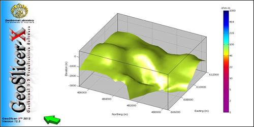
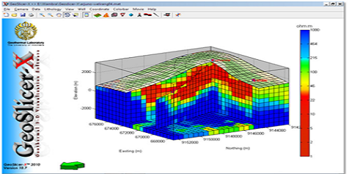
GeoSlicer-X is a software developed to help geoscientists and engineers to analyze the data in the form of geothermal 3-dimensional. The software used to perform 3-D modeling of geophysical data such as magnetotelluric data, CSAMT, gravity, geoelectric, and magnetic. In addition this software can also be used to model the geological data, such as the distribution of rocks in a region. This software can generate static images (still) or dynamic (animated). Until now, the software development process is still underway in line with the development of technology.


STATIC SHIFTER-X
This software is used to correct the static shift in the curve of Magnetotelluric method. Earlier this curve shift correction process is only done by using the curve of the other EM method TDEM the curve. However, using this software, MT curve correction can be performed using a method based on statistical data processing.There are two geostatistical methods used by this software, namely CoKriging and Averaging.


MT2DINV-X
This software is used to perform the 2-D inversion of the Magnetotelluric data. Data input for this software are period, rho TM, phase TM, rho TE, and phase TE.


MT2DFOR-X
This software is used to perform forward modeling of the data MT. From 2-D model created using this software, the data will be obtained in the form of rho and the MT phase.


MT3DINV-X
This software is used to perform the 3-D inversion of the Magnetotelluric data. MT3DInv-X can be used to facilitate in grid setting to perform 3-D inversion of MT data. The output can be integrated with 3-D visualization software, GeoSlicer-X. The result of 3-D Inversion of MT data visualized using the GeoSlicer-X software can provide information of the ‘real’ condition of the subsurface.


GRAVPRO-X
This software is developed for gravity data processing of the raw data (raw data), the data reduction and correction of gravity including digital terrain correction (digital terrain corrections) to the data obtained Complete Bouguer Anomaly. Besides with this software, can also do the 2-D modeling of gravity of data. With this software, it can also be done regional and residual separation process, First Horizontal Dervative (FHD), Second Vertical Derivative (SVD), Spectrum Analysis, and Modeling Forward 2-dimensional.


GEOCHEM-X
Software used to calculate the temperature range of an object.
